Earthquake(s)
Pre-History
- There are no recorded of events nor few about earthquake before the History was written, but it would be possibly causes by collision of Tectonic Plates and Volcanic Eruptions, resulting to an earthquakes, and forming another Mountains , Volcanoes and even Lakes.
- For example, the Taal Volcano, This is a part of a chain of volcanoes along the island of Luzon, which were formed by two tectonic plates colliding over 500,000 years ago. Since the formation of this large caldera, subsequent eruptions created another volcanic island, within Taal Lake, known as Volcano Island.[12]
Historical Era
The table below is a tally of the ten most deadliest recorded earthquakes in the Philippines since the 1600s with having the most number of casualties:
18th century
- An intensity VII struck Lake Bombon (now known as Taal Lake) on September 24, 1716. It was connected with the eruption of Taal volcano; the constant volcanic activity in the area of Taal caused seismic movements.
- An intensity IX struck Tayabas (now known as Quezon) in 1730. It had ruined the churches and convent in Mauban and several other churches in the province of Tayabas and Laguna.
19th century
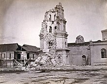
- An earthquake on June 3, 1863, destroyed the Manila Cathedral, the Ayuntamiento (City Hall), the Governor's Palace (all three located at the time on Plaza Mayor, now Plaza de Roma) and much of the city. The residence of the Governor-General was moved toMalacañang Palace located about 3 km (1.9 miles) up the Pasig River, while the other two buildings were rebuilt in place.
- An intensity X struck Luzon on July 14–24, 1880.[13] The quake caused severe damage to these major cities in Luzon, most significantly in Manila where a lot of buildings collapsed. Number of casualties are unknown.[14]
- A quake struck Lucban, Quezon on October 26, 1884. It destroyed churches in Lucban town in Quezon province and Cavinti town in Laguna province.[14]
| Ten deadliest recorded earthquakes in the Philippines since the 1600s | ||||||||||
|---|---|---|---|---|---|---|---|---|---|---|
| Magnitude | Origin | Location | Date | Mortality | Missing | Injured | Damages | Source | ||
| 1 | 7.9 | Tectonic | Moro Gulf | August 16, 1976 | 4791 | 2288 | 9928 | |||
| 2 | 7.8 | Tectonic | Luzon Island | July 16, 1990 | 1666 | 1000 | More than 3000 | ₱ 10 billion | ||
| 3 | 7.5 | Tectonic | Luzon Island | November 30, 1645 | More than 600 | More than 3000 | Unknown | |||
| 4 | 7.3 | Tectonic | Casiguran, Aurora | August 2, 1968 | 271 | 261 | ||||
| 5 | 7.2 | Tectonic | Bohol & Cebu | October 15, 2013 | 222 | 8 | 796 | ₱ 4 billion (est.) | [15] | |
| 6 | 7.1 | Tectonic | Mindoro | November 15, 1994 | 78 | 430 | ₱ 5.15 million | [16] | ||
| 7 | 6.7 | Tectonic | Negros Oriental | February 6, 2012 | 51 | 62 | 112 | ₱ 383 million | ||
| 8 | 8.3 | Tectonic | Panay (Lady Caycay) | January 25, 1948 | 50 (est) | ₱ 7 million | ||||
| 9 | Unknown | Tectonic | Manila | June 19, 1665 | 19 | Unknown | ||||
| 10 | 6.5 | Tectonic | Laoag | August 17, 1983 | 16 | 47 | ||||
| 11 | 7.5 | Tectonic | Mindanao Island | March 5, 2002 | 15 | 100 | ||||
| 12 | 7.2 | Tectonic | magnitude of 7.2 earthquake struck Bohol | October 15, 2013 | 85 |
--->
| ||||


No comments:
Post a Comment