Volcanic Eruptions
Pre-History
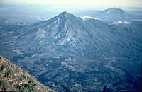
The Mt.Masaraga,The thick lava flows from Holocene period are still present on the flanks of the mountain.
| Event | Date | Notes |
|---|
| Eruption of Mount Panay | Pleistocene | Last eruptive activity is thought to be Pleistocene, about 500,000 years ago. |
| Eruption of Mount Arayat | Holocene | There are no cultural records of historical eruptions. However, weak steaming is currently present in some of the heavily eroded vents on the North Western side of the summit. The ancient eruptions were said to have caused the formation of a Lava Dome on the Western Slopes of the mountain known as White Rock which makes a nice tourist destination and is usually a field trip destination for students of Pampanga Agricultural College. The Arayat amphitheatre is said to have been caused by the summit's collapse on the western side but a much deeper crater is present on the eastern side, it was said that the mountain was once a volcanic island, until eruptions covered the surrounding area with soil, eruptions were said to be the possible cause of a theorized re-route of Pampanga River which is said to have once passed on the western side rather than eastern side where it currently moves |
| Eruption of Mount Natib | PleistoceneorHolocene | There are no historical eruptions within the Natib caldera complex. Studies in 1991 (Panum and Rayem) indicate that the last eruptive activity was probably Holocene to upper Pleistocene. An earlier study in 1971 (Ebasco Services) dated the eruptive products between 69,000 +/- 27,000 years old. |
| Eruption of Mt.Masaraga | Holocene | There are no historical eruptions from the volcano with the last eruptive activity dated as Holocene as reported by the Global Volcanism Program. Thick lava flows from that period are present on the flanks of Mount Masaraga, an understudied volcano in the Philippines. |
| Eruption of Laguna Caldera | C28,000 BP | The caldera, whose lake surface is only 1m above sea level, may have formed by least two major eruptions of about 1 million and 27,000-29,000 years ago. |
| Eruption of Mount Malinao | 60,000 BP | There are no historical eruptions from Malinao which is believed to have been active from about 500,000 years ago until 60,000 years ago. |
| Eruption of Cuernos de Negros | 12,000 BC | An earlier study in 1971 (Ebasco Services) dated the eruptive products between 69,000 +/- 27,000 years old. |
| Eruption of Ancestral Pinatubo | Holocene 1.1 million years ago | The activity of Ancestral Pinatubo seems to have begun about 1.1 million years ago and probably ended tens of thousands or more before the birth of 'Modern Pinatubo'. Much of the rugged land surrounding the present volcano consists of remnants of 'ancestral' Pinatubo. It was an andesite and dacite stratovolcano with its eruptive activity much less explosive than modern Pinatubo. |
| Eruption of Mt.Mariveles | 2050 BCE | There are no recorded historical eruptions from Mariveles caldera, with the last activity indicated byRadiocarbon dating occurring around mid-Holocene or about 2050 BCE. |
Historical Era
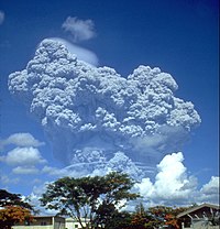
The eruption column of
Modern Pinatubo on June 12, 1991, three days before the climactic eruption.

Map of Pinatubo showing nearby peaks and the evacuation zones.
Eruptions have also destroyed numerous lakeside towns, burying them with volcanic ash or submerged them by rising lake waters displaced by the erupted material. Lipa, Taal, Sala, Bauan and Tanauan were formerly located along Taal Lake. Presently, only three towns are on the lake's shore. Remnants of the old lakeside towns are reported to be seen under the lake's waters.
[9]
| Event | Date | Notes |
|---|
| Leonard Kniaseff | c.120AD.[7] | There was a scare in 1995 but PHIVOLCS investigation at the time did not disclose any unusual activity, and no unusual activity has been reported since. |
| San Pablo Volcanic Field | 1350 AD +/- 100 | Last activity was the formation of Sampaloc Lake around 1350 AD +/- 100 years determined byanthropology[8] |
| Taal Eruption | 1572 to 1977 and 1991 | The Siries of eruptions create a Caldera Lake for a long time, Showing signs of unrest since and permanently monitored. |
| Mayon Eruption | 1616 to 2014 | The most destructive eruption of Mayon occurred on February 1, 1814 (VEI=4). Lava flowed but not as much compared to the 1766 eruption; Instead, the volcano was belching dark ash and eventually bombarded the town of Cagsawa with tephra that buried it. Trees were burned; rivers were certainly damaged. Proximate areas were also devastated by the eruption, with ash accumulating to 9 m (30 ft) in depth. In Albay, a total of 2,200 locals perished in what is considered to be the most lethal eruption in Mayon's history; estimates byPHIVOLCS list the casualties at about 1,200, however. The eruption is believed to have contributed to the accumulation of atmospheric ash,[citation needed] capped by the catastrophic eruption of Mount Tambora in 1815, that led to the Year Without a Summer in 1816. |
| Pinatubo Eruption | 1500 and 1991 | Reawakened in 1990 producing the 2nd largest eruption in the 20th century. Followed by milder eruptions in 1992 and 1993,On July 16, 1990, the major 1990 Luzon earthquake of magnitude 7.7 struck central Luzon. This was the largest earthquake recorded in 1990,[10] |
| Mt.KanlaonEruption | 1886 to 2006 | The most active volcano in central Philippines, Kanlaon has erupted 26 times since 1919. Eruptions are typically phreatic explosions of small-to-moderate size that produce minor ash falls near the volcano. In 1902, the eruption was classified as strombolian, typified by the ejection of incandescent cinder, lapilli and lava bombs. |
| Bulusan Eruption | 1886 to 2011 | Bulusan is generally known for its sudden steam-driven or phreatic explosions. It has erupted 15 times since 1885 and is considered as the 4th most active volcano in the Philippines after Mayon, Taal, and Kanlaon, There are evacuation procedures in place for parts of the peninsula, the farms nearest the volcano are evacuated, and many of the village schools are closed if it is considered possible that a more destructive eruption could occur. |
| Mt.Hibok-hibok Eruption | 1827, 1862, 1871 and 1948–1952 | On February 16, 1871, earthquakes and subterranean rumblings began to be felt on the island, which increased in severity until April 30 when a volcanic fissure opened up 400 yards southwest of the village of Catarman, on the northwest flank of Hibok-hibok Volcano. From the opening, lava was continuously ejected and poured into the sea for four years destroying the town. At the same time, the vent started gaining in height and width thus forming Mt. Vulcan. In 1875, the Challenger expedition visited the area, and described the mountain as a dome, about 1,950 feet (590 m) in height, without any crater, but still smoking and incandescent at the top.[11] |


No comments:
Post a Comment